TANK TRAPS NEAR TENTERFIELD,
NSW
DURING WW2
![]()
Concrete Tank Traps were built during WW2 to span a bottle neck in the Clarence River Valley, east of Tenterfield in northern New South Wales, in an area known as Paddys Flat. The concrete pillars are still visible in and beside the river near the crossing.

Photo:- Peter Moll
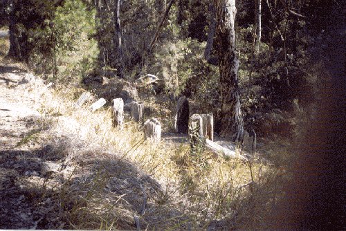
Tank Trap at Paddy's Flat near the Clarence River near Tooloom, NSW

Photo:- Peter Moll
Tank Trap at Paddy's Flat

Photo:- Scott Leach
Tank Traps uncovered following recent flooding in 2011

Photo:- Scott Leach
Close-up of exposed Tank Traps
It has been suggested by some that these Tank Traps were part of the so-called "Brisbane Line" defence plan. There are some other well known tank traps just north of Tenterfield on the Bald Rock Road. They consist of log pillars and a concrete wall in the valley. The sign posts on the road suggest that they formed part of the so-called "Brisbane Line" defences. The actual existence of the "Brisbane Line" is still very much open for debate. The tank traps are about 1 km north of London Bridge where there was a large army camp during WW2. There was up to 10,000 soldiers camped in the Tenterfield area during WW2.
The timber tank traps near both the Mount Lindsay Highway and the Bruxner Highway are of similar construction approximately 4 rows of wooden posts, evenly spaced. The one near the Bruxner Highway have been badly fire damaged in recent years.
 |
Sign on side of near the Mount Lindsay Highway?? on Bald Rock Road just north of Tenterfield?? (Photo - Bill Durrant) |
 |
Information sign which claims that the role of these Tank Traps was part of the so-called Brisbane Line Defence scheme. (Photo - Bill Durrant). |
 |
Tank Traps near the Mount Lindsay Highway (Photo - Bill Durrant) |
 |
Tank Traps near the Mount Lindsay Highway (Photo - Bill Durrant) |
 |
Concrete wall (Photo - Bill Durrant) |
 |
Tank Traps near the Bruxner Highway approximately 27.5 kms from the outskirts of Tenterfield, on the way to Casino. They are not sign-posted. They may be an extension of the line of tank-traps extending from the Mount Lindsay Highway which is not that far away. (Photo - Bill Durrant) |
 |
Tank Traps near the Bruxner Highway. These tank traps are on both sides of the road and are very easy to miss, as they are on a down-hill section of road just before a sharp bend. (Photo - Bill Durrant) |
 |
Tank Traps near the Bruxner Highway. The tank-traps on the left-hand side of the road are not visible, unless you get out of your car and look down over the side of the road. They extend for approximately 70 metres. The tank traps on the right-hand side extend up and over the crest of the hill and partly down the other side. Approximately 150 metres in length overall, for the uphill section. A small section has been bull-dozed. (Photo - Bill Durrant) |
 |
Tank Traps near the Bruxner Highway (Photo - Bill Durrant) |
ACKNOWLEDGEMENTS
I'd like to thank Dallas Goodwin from Mt. Isa and Bill Durrant from Wallangarra, QLD for their assistance with this home page.
I'd also like to thank Peter Moll for his assistance with this web page.
Can anyone help me with more information?
"Australia @ War" WWII Research Products

|
|
© Peter Dunn 2015 |
Please
e-mail me |

This page first produced 1 December 2001
This page last updated 25 January 2020

