NAVAL MAGAZINE
AND
MINE ASSEMBLY DEPOT LOCATIONS
ON MOUNT COOT-THA DURING WWII
![]()
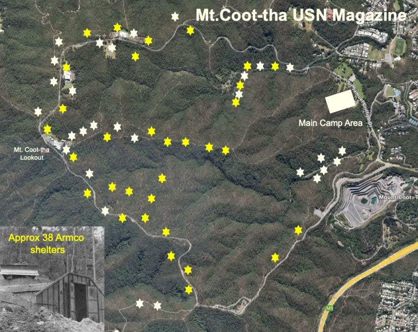
Rough locations of shelters and other buildings
on Mt Coot-tha based on
55th Seabees
Plan (NAA150/1/525/20, I195) of Mount
Coot-tha Naval Magazine and Mine Assembly Depot
Around Mount Coot-tha
| Site ID | Description | Notes |
| 1 | Armco Magazine M1 | Nothing clearly visible at site. |
| 2 | Armco Magazine M2 | One edge of the concrete foundation was exposed to view in 2018 |
| - | - | There is no Number 3 shown on the Plan. It may possibly relate to the "old non-magnetic hut" 20' x 30' that was originally located at the junction of Sir Samuel Griffith Drive and the Honeyeater Track/Reservoir Trail, located near No. 4 on the plan. |
| 4 | No name shown | This was situated beside the Reservoir Trail not far from the junction with the Chapel Hill Road Trail. All that remains of it in 2018 is a concrete slab covered in thick grass. |
| 5 | Armco Magazine A1 | |
| 6 | Armco Magazine M4 | |
| 7 | Armco Magazine A2 | |
| 8 | Armco Magazine A3 | Exact location uncertain in 2018 |
| 9 | Armco Magazine M6 | Exact location uncertain in 2018 |
| 10 | Armco Magazine M8 | In 2018 the concrete foundation and some scrap metal remains were still visible alongside the Litchfield Trail |
| 11 | Armco Magazine MV | This should possibly have read as "M5". An easy walk from the Litchfield Trail. |
| 12 | Armco Magazine A4 | In 2018 one concrete edge of the foundation was clearly exposed to view. |
| 13 | Armco Magazine A6 | Overlooks the Litchfield Track near the Gold Mine Picnic area. |
| 14 | Armco Magazine A7 | Overlooks the Litchfield Track. |
| 15 | Fibrolite Hut A5 | |
| 16 | Armco Magazine A7 | That makes two A7s? Obviously an oversight. This site was still covered by a heavy layer of soil in 2018, with nothing directly visible. |
| 17 | Fibrolite Hut A8 | Nothing clearly visible at site. |
| 18 | Fibrolite Hut A9 | Nothing clearly visible at site. |
| 19 | Fibrolite Hut A10 | Nothing clearly visible at site.. |
| 20 | Armco Magazine A11 | Nothing clearly visible at site. |
| 21 | Fibrolite Hut A12 | Nothing clearly visible at site. |
| 22 | Quonset Hut A14 | Nothing clearly visible at site. |
| 23 | Quonset Hut A16 | Nothing clearly visible at site. |
| 24 | Quonset Hut A15 | Nothing clearly visible at site. |
| 25 | Armco Magazine A18 | Nothing clearly visible at site. |
| 26 | Quonset Hut A17 | There are some depressions here and possible evidence of a turnaround for trucks, but there is nothing clearly visible at site of the Quonset Hut. |
| 27 | No name shown | Probably not built |
| 28 | Armco Magazine A19 | Nothing clearly visible at site. |
| 29 | Armco Magazine M14 | The concrete foundation is clearly visible off the northern side of the Powerful Owl Trail, but it is still easy to walk past this. |
| 30 | Armco Magazine M15 | The exposed concrete edge of this can be clearly seen alongside northern side of the Powerful Owl Trail. |
| 31 | Armco Magazine M16 | The concrete foundation is hidden off the southern side of the Powerful Owl Trail, but is still there. |
| 32 | Armco Magazine M17 | This was at the end of the trail constructed by the Seabees. While not clearly visible, it is easy to envisage where this turnaround area was located. |
| 33 | Armco Magazine M18 | This is on the site of the Channel 9 Television property, and as such this is a site that is not publicly accessible. Probably nothing to see there anyway. NOTE: There was also "Detonator Locker #1" located nearby, also on the Channel 9 site, which is shown on the map with no location number. |
| 34 | Fibrolite Hut A20 | |
| 35 | Armco Magazine A21 | No physical evidence of this was seen in 2018. |
| 36 | Fibrolite Hut A22 | This concrete foundation is located at a lonely bush spot some 100 metres from the road, in the bush. It is in very poor, exposed condition but in the right light makes for an impressive photo. |
| 37 | Fibrolite Hut A23 | |
| 38 | Armco Magazine M20 | The remains of this Armco Magazine, if any are left, will be under grass within the property of the Channel 7 Television site. As such there is no public access. |
| 39 | Quonset Hut A24 | This site is located across the road opposite Channel 7. There was nothing obviously visible to be seen here in 2018. |
| 40 | Fibrolite Hut A25 | There was no physical sign of the foundation visible in 2018. |
| 41 | Armco Magazine M34 | |
| 42 | Fibrolite Hut A26 | This magazine would have been situated at the current ABC TV site; it is not accessible to the public. |
| 43 | Fibrolite Hut A37 | This magazine would have been situated at the current ABC TV site; it is not accessible to the public. |
| 44 | Armco Magazine M23 | This magazine would have been situated at the current ABC TV site; it is not accessible to the public. |
| 45 | Armco Magazine M22 | This would have been located beside the current Channel 10 TV Studio site. It is not accessible to the public. |
| 46 | Fibrolite Hut A28 | This would have been located within the modern Channel 10 TV Studio site. It is not accessible to the public. |
| 47 | Armco Magazine A30 | The exposed concrete edge is visible beside the bitumen road. |
| 48 | Fibrolite Hut A31 | |
| 49 | Armco Magazine M35 | |
| 50 | Not named | The lack of a name on the plan probably means that there was open storage of ammunition at this site with no building constructed. |
| 51 | Armco Magazine M25 | |
| 52 | Not named | The lack of a name on the plan probably means that there was open storage of ammunition at this site with no building constructed. |
| 53 | Armco Magazine M26 | |
| 54 | Not named | The lack of a name on the plan probably means that there was open storage of ammunition at this site with no building constructed. This location is now a car park at Simpsons Falls Picnic Area. |
| 55 | Armco Magazine M27 | |
| 56 | Not named | The lack of a name on the plan probably means that there was open storage of ammunition at this site with no building constructed. This location is now a car park at Simpsons Falls Picnic Area. |
| 57 | Armco Magazine M28 | This location is now the last car park and turnaround area at the Simpsons Falls Picnic Area. A small section of the original concrete foundation of Armco M28 was visible through the bitumen cover in 2018. |
| 58 | Not named | The lack of a name on the plan probably means that there was open storage of ammunition at this site with no building constructed. This was located on what is now the Reservoir Trail. |
| Not built Armco M24 (near 47) | ||
| Detonator Locker No. 1 | Located near 33. | |
| Detonator Locker No. 2 | Detonator Locker No. 2 was just around the corner as you drive downhill from No. 47, in the clockwise direction. It has no location number on the map. | |
| Detonator Locker No. 3 | Located near 49. | |
| Detonator Locker No. 4 | Located near 49. | |
| Detonator Locker No. 5 | Located on the left across the creek just past the Assembly Plant building. The remains of Detonator Locker No. 5 still exist. This was probably the smallest Detonator Locker at Mount Coot-tha. | |
| Water tanks | Located near No. 17. | |
| Old non magnetic hut | located near No. 5. | |
| Kiosk Hut |
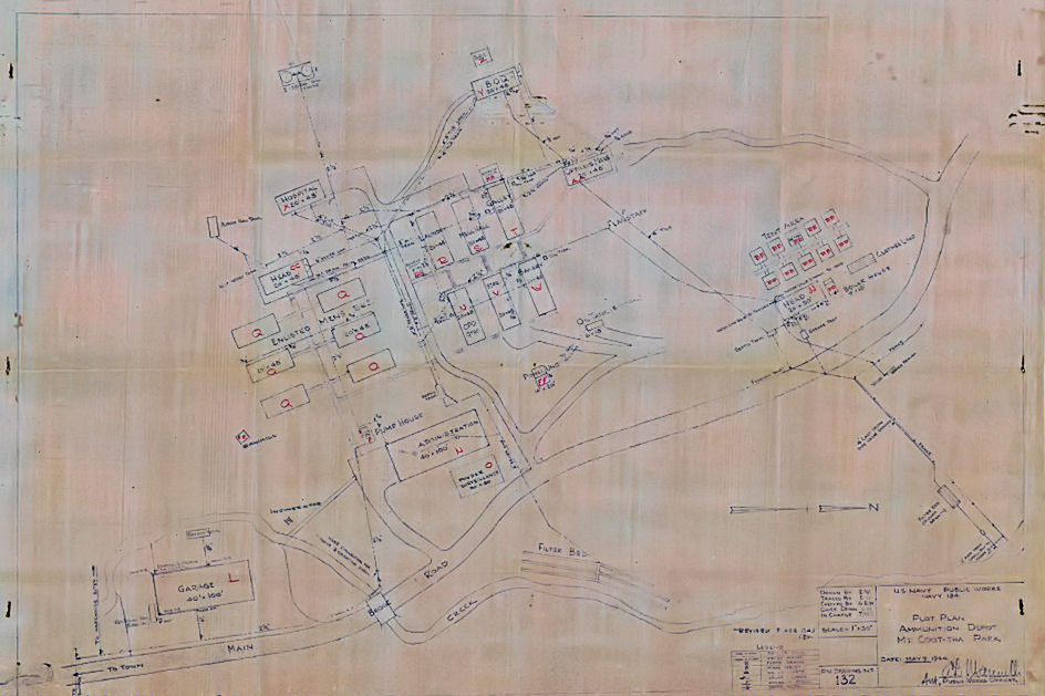
Plan:- NAA MP 742/1:259/54/807
Plan of the Main Camp Area
Main Camp Area
| Site ID | Description | Notes |
| AA | Officers Mess 20' x 48' | |
| BB | Tent Area. 10 tents each 16' x 16' | These tents were provided as Officers Quarters. They were erected on a wooden base and were fitted out with electric light. |
| CC | Head 20' x 48' | This was the enlisted men's toilet and shower block. |
| DD | Boiler House | The Boiler House was erected to supply hot water to the Officers Toilet Block and Recreation building (labelled as "Head JJ"). There was a hot water tank similarly positioned outside the enlisted men's ablution block at "Head CC". |
| EE | Sawmill | |
| FF | Power Unit | |
| GG | Barber Shop | |
| HH | Garbage Shack | |
| JJ | Head 20' x 50' | This building provided shower and toilet facilities for the officers living in tent accommodation, and probably included separate recreation and office areas as well. |
| L | Garage 40' x 100' | |
| N | Administration 40' x 100' | |
| O | Powder Surveillance 30' x 50' | |
| P | Pump House | |
| Q1 | Enlisted Mens Barracks 20' x 48' | |
| Q2 | Enlisted Mens Barracks 20' x 48' | |
| Q3 | Enlisted Mens Barracks 20' x 48' | |
| Q4 | Enlisted Mens Barracks 20' x 48' | |
| Q5 | Enlisted Mens Barracks 20' x 48' | |
| Q6 | Enlisted Mens Barracks 20' x 48' | |
| R | Laundry 20' x 48' | |
| S | Mess Hall 20' x 48' | |
| T | Galley 20' x 48' | |
| U | Chief Petty Officers Quarters 20' x 48' | |
| V | Store 20' x 48' | |
| W | Bakery 20 ' x 48' | |
| X | Hospital 20' x 48' | Probably just a Sick Bay |
| Y | Bachelor Officers Quarters BOQ 20' x 48' | |
| Z | Washroom and toilets for BOQ | |
| - | Rifle Range (slightly to the north west of the main camp area) |
J.C. Slaughter Falls area
| Site ID | Description | Notes |
| E | Assembly Plant Building | |
| F | New non magnetic hut | Slab now used for post WWII Bush Chapel) |
| J1 | Warehouse Building 1 | Now a Car Park area |
| J2 | Warehouse Building 2 | Now a Car Park area |
| J3 | Warehouse building 3 | Now a Car Park area |
| K | 20' x 25' shelter |
Adjacent to the Naval Magazine and Mine Assembly Depot
| Description | Notes |
| Pump House | Southern Cross Diesel pump engine and two pumps |
| Two circular water tanks | Concrete water tanks |
REFERENCE BOOKS
"History of Mount Coot-tha" by Janet Spillman
ACKNOWLEDGEMENTS
I'd like to thank Allan Tonks for his assistance with this web page.
Can anyone help me with more information?
"Australia @ War" WWII Research Products

|
|
© Peter Dunn 2015 |
Please
e-mail me |

This page first produced 6 November 2018
This page last updated 16 May 2024

